![](/images/other/stat-length.png)
![Trail On foot Piazza Brembana - Sentiero 128: Piazza Brembana - Cespedosio - Photo](https://media.geolcdn.com/t/1900/400/760dd934-c1b1-47d2-ad99-ffb9346e04b9.jpeg&format=pjpeg&maxdim=2)
Sentiero 128: Piazza Brembana - Cespedosio
SityTrail - itinéraires balisés pédestres
Tous les sentiers balisés d’Europe GUIDE+
![Length](/images/other/stat-length.png)
![Max alt](https://static1.geolcdn.com/siteimages/upload/files/1508320355ic_sort_altitude_max_24dp.png)
![Uphill gradient](https://static1.geolcdn.com/siteimages/upload/files/1508320355ic_sort_den_pos_24dp.png)
![Km-Effort](/images/other/stat-length.png)
![Min alt](https://static1.geolcdn.com/siteimages/upload/files/1508320355ic_sort_altitude_min_24dp.png)
![Downhill gradient](https://static1.geolcdn.com/siteimages/upload/files/1508320355ic_sort_den_neg_24dp.png)
![Boucle](https://static1.geolcdn.com/siteimages/upload/files/16400158638029165_repeat_loop_refresh_sync_direction_icon.png)
![On foot](https://static1.geolcdn.com/sitytour/trail-icons/100.png)
4h06
Difficulty : Easy
![Scan this QR Code to open this trail in the SityTrail application](https://capi.geolives.com/qq0zvz2zws4bq2lad0pu/sitytour/trails/3124061/qr.png?size=200)
FREE GPS app for hiking
About
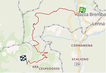
Trail On foot of 7.5 km to be discovered at Lombardy, Bergamo, Piazza Brembana. This trail is proposed by SityTrail - itinéraires balisés pédestres.
Description
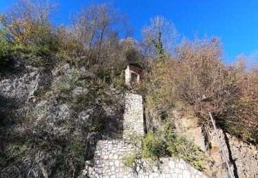
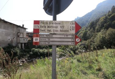
Da Piazza Brembana si scende verso il fiume Brembo di Mezzoldo, verso la località "i Fondi", trovando subito uno spiazzo a uso parcheggio; si attraversa un caratteristico ponte (a quota 493 m circa) con torre finale, giungendo in un ameno spiazzo erboso con un vecchio rudere e la Cappelletta dei Fondi: siamo già sul 128.
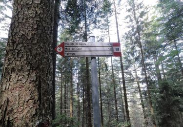
Website: http://geoportale.caibergamo.it/sentiero/128
Positioning
Comments
Trails nearby
![Trail On foot Olmo al Brembo - Sentiero 129A: Olmo al Brembo - Piazza Brembana - Photo](https://media.geolcdn.com/t/375/260/760dd934-c1b1-47d2-ad99-ffb9346e04b9.jpeg&format=jpg&maxdim=2)
![On foot On foot](https://static1.geolcdn.com/sitytour/trail-icons/100.png)
On foot
![](/images/other/stat-length.png)
![](https://static1.geolcdn.com/siteimages/upload/files/16400158638029165_repeat_loop_refresh_sync_direction_icon.png)
![Trail On foot Lenna - Sentiero 269: Lenna (Cantone San Francesco) - Roncobello - Photo](https://media.geolcdn.com/t/375/260/a4fae432-50cb-44b4-9bda-feda9a2bd824.jpeg&format=jpg&maxdim=2)
![On foot On foot](https://static1.geolcdn.com/sitytour/trail-icons/100.png)
On foot
![](/images/other/stat-length.png)
![](https://static1.geolcdn.com/siteimages/upload/files/16400158638029165_repeat_loop_refresh_sync_direction_icon.png)
![Trail On foot Moio de' Calvi - Sentiero 126: Moio de' Calvi - Monte Torcola - Photo](https://media.geolcdn.com/t/375/260/a66cadce-b960-421f-819b-1364f5662a4e.jpeg&format=jpg&maxdim=2)
![On foot On foot](https://static1.geolcdn.com/sitytour/trail-icons/100.png)
On foot
![](/images/other/stat-length.png)
![](https://static1.geolcdn.com/siteimages/upload/files/16400158638029165_repeat_loop_refresh_sync_direction_icon.png)
![Trail On foot Piazza Brembana - Sentiero 123: Piazza Brembana - Roccolo di Calche - Photo](https://media.geolcdn.com/t/375/260/760dd934-c1b1-47d2-ad99-ffb9346e04b9.jpeg&format=jpg&maxdim=2)
![On foot On foot](https://static1.geolcdn.com/sitytour/trail-icons/100.png)
On foot
![](/images/other/stat-length.png)
![](https://static1.geolcdn.com/siteimages/upload/files/16400158638029165_repeat_loop_refresh_sync_direction_icon.png)
![Trail On foot Olmo al Brembo - Sentiero 129: Olmo al Brembo - Roccolo di Calche - Photo](https://media.geolcdn.com/t/375/260/014ff2b6-1b3d-4584-a37f-8208c225d628.jpeg&format=jpg&maxdim=2)
![On foot On foot](https://static1.geolcdn.com/sitytour/trail-icons/100.png)
On foot
![](/images/other/stat-length.png)
![](https://static1.geolcdn.com/siteimages/upload/files/16400158638029165_repeat_loop_refresh_sync_direction_icon.png)
![Trail On foot Olmo al Brembo - Sentiero 127: Cugno di Sotto (Olmo al Brembo) - Baita Maffenoli - Photo](https://media.geolcdn.com/t/375/260/014ff2b6-1b3d-4584-a37f-8208c225d628.jpeg&format=jpg&maxdim=2)
![On foot On foot](https://static1.geolcdn.com/sitytour/trail-icons/100.png)
On foot
![](/images/other/stat-length.png)
![](https://static1.geolcdn.com/siteimages/upload/files/16400158638029165_repeat_loop_refresh_sync_direction_icon.png)
![Trail On foot Piazza Brembana - Sentiero 127A: Piazza Brembana (loc. i Fondi) - Olmo al Brembo (fraz. Cugno) - Photo](https://media.geolcdn.com/t/375/260/9d67b535-4b05-4006-ba0e-37dc10f33dd2.jpeg&format=jpg&maxdim=2)
![On foot On foot](https://static1.geolcdn.com/sitytour/trail-icons/100.png)
On foot
![](/images/other/stat-length.png)
![](https://static1.geolcdn.com/siteimages/upload/files/16400158638029165_repeat_loop_refresh_sync_direction_icon.png)
![Trail On foot Valnegra - Sentiero 119: Valnegra - Monte Torcola - Forcolino di Torcola - Photo](https://media.geolcdn.com/t/375/260/0b53ae85-4fb7-490e-88e3-eb051f183083.jpeg&format=jpg&maxdim=2)
![On foot On foot](https://static1.geolcdn.com/sitytour/trail-icons/100.png)
On foot
![](/images/other/stat-length.png)
![](https://static1.geolcdn.com/siteimages/upload/files/16400158638029165_repeat_loop_refresh_sync_direction_icon.png)
![Trail On foot Cassiglio - Sentiero delle Orobie Occidentali - Tappa 1 - Photo](https://media.geolcdn.com/t/375/260/09d510e2-f6ad-4996-b599-3605221ca888.jpeg&format=jpg&maxdim=2)
![On foot On foot](https://static1.geolcdn.com/sitytour/trail-icons/100.png)
On foot
![](/images/other/stat-length.png)
![](https://static1.geolcdn.com/siteimages/upload/files/16400158638029165_repeat_loop_refresh_sync_direction_icon.png)